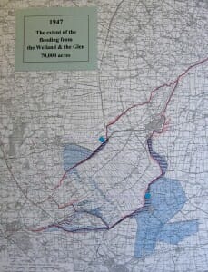
This map shows the areas which were flooded by the Rivers Glen & Welland in 1947. The large blue area on the map is from Little London, Spalding down to the Crowland area.
Who has memories of these floods, and the areas effected ?
Click on image to enlarge


2 Responses
I was a very young child and living opposite the Chain Bridge Forge when the 47 floods occurred. I recall the tension in the air and the men urgently filling sandbags to prevent water coming into the homes. I remember being frightened but either I was reassured by my parents or the flooding was not quite as severe as anticipated in that area of Albion Street.
Thanks for that lovely memory
Regards
Geoff Taylor