The Wash is a bay on the East coast of England between the Counties of Lincolnshire and Norfolk. It is a unique area of relatively shallow water which over the years has been influenced by siltation particularly adjacent to the coastal fringes. Over the centuries progressive reclamations have decreased the area of the Wash at the same time making the rich alluvial deposit available for agricultural use.
Apart from a section of the Norfolk coastline, inland from these reclamations is a low lying area known in a general term as ‘the Fens’. Over the centuries the fens have been subjected to flooding by waters carried down from the uplands by the rivers and from inundation by the sea. As a result they have often suffered from an unsayoury reputation. Sir William Dugdale who travelled through the fens in 1657 quotes “the air being for the most part cloudy, gross and full of rotten harrs; the water putrid and muddy, yea, full of loathsome vermin; the earth spungy and boggy, and the fire noisome, by the stink of smoaky hassocks.” There is however considerable evidence of Roman British occupation between the 1st and 4th Centuries A.D. Towards the end of the 4th Century there was a period of subsidence with consequent flooding. Fenland conditions generally remained unsavoury for many centuries with frequent flooding both from rivers and the sea. It was not until the 17 century that Crown grants were made to Adventurers and reclamation projects began. The Adventurers were rewarded with grants of land to recompense the expenses they incurred.
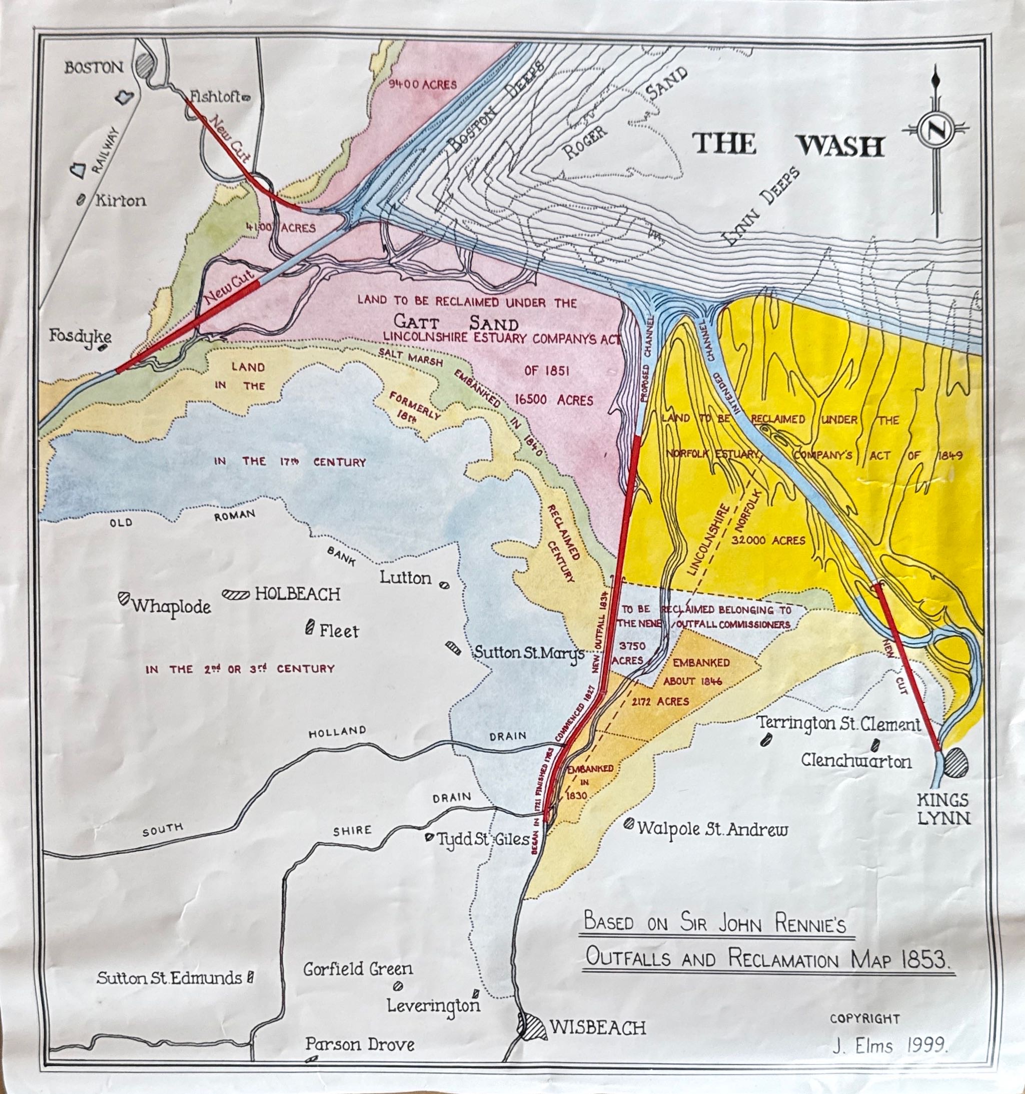
The four major rivers which now discharge into the Wash have considerable influence over the fenland regions. Commencing to the East the rivers are the Great Ouse, Nene, Welland and Witham. The Romans it seems were the first to seriously attempt to drain the fens by isolating them from the upland waters and embank them against the flooding from the sea. In Roman times the Witham flowed into the sea considerably to the North of its present outfall while the Nene and Great Ouse both met near Wisbech with only the Little Ouse joining the sea near Kings Lynn. The Romans also regarded the natural rivers as major arterial watercourses and led the subsidiary drains into them. Many of the later drainers neglected this principle by trying to make nature subservient to art.
The rivers were not contained, having very shallow gradients through the low fenlands they were subject to siltation, tidal influence and frequent changes of route. The ports of Kings Lynn, Wisbech, Spalding and Boston together with the outfalls of internal drainage systems, were greatly disadvantaged. The map has been produced based on proposals put forward by the celebrated engineer Sir John Rennie in the middle of the nineteenth century. It will be observed not all the ideas come to fruition. The outfall of the Great Ouse is much further to the East and the reclamations do not all follow the proposals particularly on the Norfolk frontage where the reclaimed area is considerably less. The containment of the outfall channels by means of embankments did however bring considerable advantages, the ports of Kings Lynn, Wisbech, Sutton Bridge, Fosdyke (navigation for shipping is no longer possible into Spalding) and Boston all remain in use and the Rivers provide more adequate outfalls for internal drainage systems. There are a number of smaller arterial channels other than the main rivers which discharge into the Wash. The latter however are no longer all dependant upon gravity outfalls with the modern pumping technology available. A new bridge (Sutton Bridge) and an embankment across Sutton Wash formed a road link between Lincolnshire and Norfolk.
At the present time there is a moratorium on further reclamation in the Wash although siltation continues. It is important therefore that the maintenance of the rivers and sea defences continue to ensure the surrounding fenlands remain as we know them today. Fascine works, now a days mainly using stone, together with dredging remain ongoing projects to maintain the channels profiles.
As already stated the map has been redrawn based upon Rennie’s original on which there was no scale. The scale of my production can however by taken as approximately two miles to one inch.
J.Elms. 1999.